Summer Weather Outlook
Weather Summary
Temperatures this summer are generally expected to be seasonally warm and total precipitation is expected to be average to below average statewide. Rapid drought development or intensification is not likely but cannot be discounted.
The Official CPC Outlook
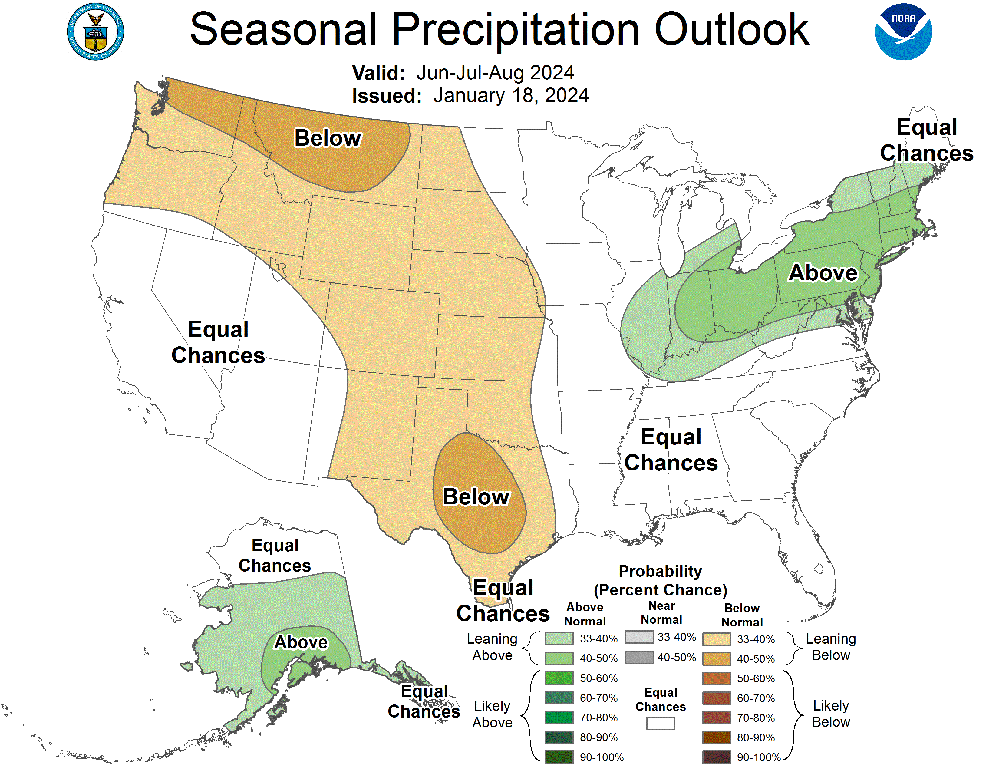
The CPC released its latest summer outlook 2024 back on Thursday, February 15th with a projection of ‘Equal Chances’ for above, below, and average temperatures and a slightly better than average chance at below average precipitation for northeast Nebraska. (Imperfect) Analogs 2016, 2010, 1998, 2003, 1995
La Nina/ENSO
El Nino has been a dominant player in global weather for the past several months but has already peaked and is starting to transition to atmospheric and oceanic neutral conditions. Most model projections of ENSO show the central Pacific going into neutral conditions by early summer and into a weak La Nina state by late summer. A few models are aggressive at developing a stronger La Nina by fall but those are the outliers. I’m not buying the aggressive push into a strong La Nina by mid-summer, but I am buying the consensus projection of weaker La Nina.
Should I be afraid of La Nina? The biggest question on most of your minds is probably “What does this mean for our weather this summer?” The answer is that it sort of depends on what happens in the North Pacific and where the Bermuda High is located. If the North Pacific goes over cold in the next several months with the developing La Nina, the likelihood of stronger upper-level ridging becoming more dominant in the north central U.S. goes up. This would increase the possibility of a drier summer and drought development or intensification in the Western Corn Belt and Central Great Plains during the growing season. The possibility of a drier than average summer is a real one and I cannot discount another year of drought and intermittent heat waves for our core grain producing regions.
The Good News
1) Most of the state is currently free of drought and for much of western Nebraska, this is the longest drought free stretch since the late 2010’s. Root zone soil moisture percentiles are in the near-normal range for most of the state. Thus, we are going into the growing season in better shape than in some recent years. But much of eastern Nebraska still needs several more inches of moisture in the next few months to get significant recharge that we need.
2) A wetter than average spring is projected for the state. If that comes to fruition as expected, then there should be adequate root zone soil moisture going into the summer. If that is indeed the case, a two week dry spell in June or July may not be optimal for people trying too hard to keep yards green but our agricultural fields and grasslands will have a reserve (that was not available last year) to tap into.
3) The official CPC forecast of drier than average does not give any indication to magnitude of dryness or timing of precipitation. A 10% reduction in precipitation for the summer is manageable, especially if precipitation comes at the right times (as it did for most in 2016). That would keep pastures and croplands in reasonably good health. A 50% reduction in precipitation that is centered on July and August is a good recipe for explosive drought development and/or intensification. The former is the more likely scenario thankfully.
4) The official CPC forecast for below average summer precipitation could be wrong. That would certainly not be unprecedented. For what it’s worth, a composite of the analogs has a wetter signal in the eastern section of Nebraska and no strong dry signal in central or western Nebraska.
5) The warm signal for the summer is more likely to be realized through warmer minimum temperatures than a series of major heat waves. While the higher minimum temperatures aren’t optimal, past precedent would suggest our area is not the most likely location for a prolonged midsummer heat wave.
Next 90 days are critical
The summer of 2024 may depend heavily on how the spring goes. IF we get ample rainfall in the next 90 days, as currently expected, then we should have a reserve of soil moisture to work with should we turn dry for a few weeks in early summer. This means crops and pastures can maintain relative health and evapotranspiration (ET) will only be reduced modestly instead of significantly. The distinction is critical. A marginal reduction in ET means there is still some “local source” of moisture to work with when frontal passages and shortwaves move into our region (making thunderstorms more likely). In this scenario, even if we end up with some periods of time under a ridge with drier weather, the good start to the summer would make it less likely we end up with a situation where dry begets dry for the entire season. However, IF this spring ends up being on the dry side and soil moisture isn’t meaningfully replenished this spring, this summer has the chance to go sideways in a hurry. This is especially the case if the North Pacific goes over cold and the atmosphere favors more ridging in the north central U.S. In this scenario, even if we get occasional frontal passages and cooler temperatures, the significant reduction in ET from the depletion of soil moisture increases the probability that future fronts go through without producing enough moisture to give us much soil moisture recharge. This positive feedback cycle between the land and atmosphere is how we end up with flash droughts and cascading impacts like reduced yields.

Online Beef Cattle Production
Master of Applied Science
Develop an understanding of beef production as a system and be exposed to alternative production practices that may enhance profitability and stewardship.